The major broadcast meteorologist are all talking about how upper air temps are warm, which will turn all of this snow and mixed precipitation to rain near the coast. So, lets take a look at upper air temperatures and see if they are right.
First, look at this image of upper air temps from yesterday at 7am EST (00Z):
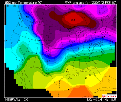
Note, that polar low has some extremely cold air with it in southern Canada and the freezing line is right around northern Virginia.

The freezing line (light blue) moved from southern Maryland up to southern NJ. We'll have to see how that progresses this morning, but if that line accelerates as I expect it will, a quick changeover to plain rain will occur starting in southern NJ now through mid New Jersey by 11am. However, there is still a ton of cold air aloft here, so I would not expect a changeover to plain rain for NYC or surrounding northern suburbs until later this afternoon as this cold air is firmly in place. By then, the storm may be past us and the winds shift to NW where the temps drop again. That cold polar air that is sitting just southwest of the Hudson Bay will filter in when the storm moves past the NY Metro area and the winds switch from northeast to northwest.
No comments:
Post a Comment