WARNING: Long post, better displayed on a monitor or tablet than a smartphone; may contain nerdish and boring content.
When I first started observing weather over 30 years ago, I was fascinated and confused how the very macro picture, like warm sea surface temps, connects with micro climate features like development of one thunderstorm cell over a very small area. These macro features are an important part of our climate and weather, and especially important for long range forecasting and prediction of winter weather. When I was a kid, unlocking these mysteries was more difficult. Now, a little google searching and you can teach yourself that high pressure in Greenland may result in more snow in New York City next month!
While I am still learning, I would like to share one recent connection point and explain how it works because I see a lot of it mentioned recently in the twittersphere by both professional meteorologists, like John Homenuk in this post from Dec 23 and more amateurish folks like myself: The Greenland High and High Latitude Blocking. This blog will explain what these are and their impact on snowfall for the mid-Atlantic and New England region.
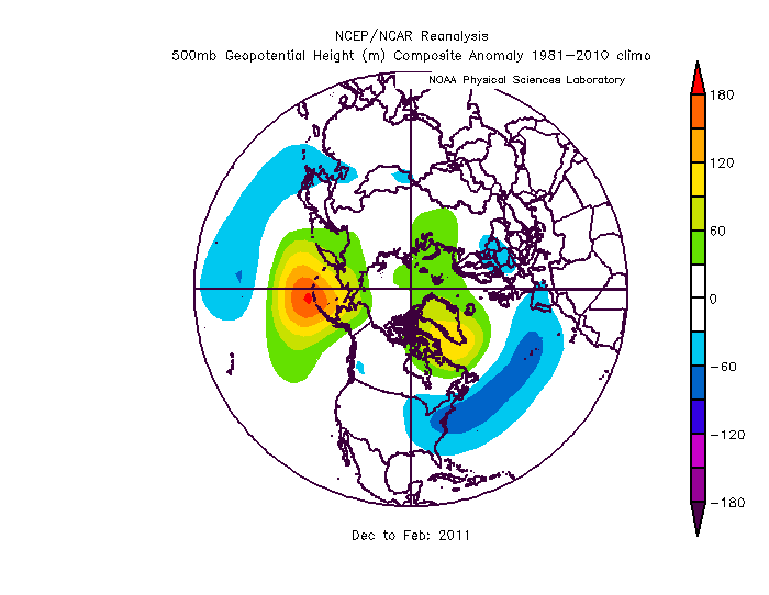
At a real basic level, the development of a strong high pressure system near Greenland and high latitude blocking results in a higher probability of a stormy, cold snowy pattern for the northeast US. For some evidence, take a look at the WDHD News7 Boston weather blog, where in his 20-21 Winter Outlook, Certified Broadcast Meteorologist Jerry Reiner very neatly explains how the 2010-11 winter was the exception to the rule of recent Strong La Nina winters bringing milder, less snowy winters to Boston. High latitude blocking and the development of a strong Greenland High as shown in the graphic below from NCEP/NCAR coincided with above normal snowfall for Boston that year:

To quote :
"That winter featured some incredible High Latitude Blocking (the warm colors near Greenland as well as the Aleutian Islands). That high latitude (Greenland) blocking led to a very active and cold storm track for the New England for much of the winter. Boston received 60” of snow in December-January!"
Why is this? And what does this mean for the rest of the winter for us?
OK, so High Latitude Blocking essentially means that there is a strong upper level high pressure that sits in the Arctic for an extended period of time. To understand why this results in cold, snowy weather for the northeast, it requires an uber-technical discussion. This would really be best explained by someone with more and better training in atmospheric science than I. However, I am qualified to provide the cliff notes for this great set up. I will borrow from Meteorologist Paul Dorian at Perspecta Weather's winter outlook and break it down this way :
1. Big northeast snowstorms require several ingredients - persistent, sustained cold air and moisture are the two most important ones.
2. "Without this type of blocking pattern in the upper atmosphere, it is more difficult to get sustained cold air masses in the central and eastern US as well as, in turn, accumulating snowfall."
Paul's discussion goes into a great bit more detail and also introduces the concepts of AO and NAO which are related but I will leave out of scope for this discussion. The other factor I would mention is that generally, you need high level blocking on both the Pacific (Alaska) and Atlantic (Greenland) sides of North America as shown in the graphic above for 2010-11 to see the most direct correlation.
The bottom line is that these blocking patterns tend to bring more sustained and persistent cold air masses into the northeast so that when there is some jet stream amplitude or moisture from an upper air disturbance that swings through and off the mid-Atlantic coast, there is cold air "locked in" and the precipitation that falls is generally in the form of snow.
And while there are countless examples of weather nerds and snow weenies posting on twitter (try it, search Greenland High on Twitter) and how this will mean more snow for us, now you know why. Whether it will or not is really anyone's guess. That said, I am watching the models and tweets closely as the consensus seems to be a strong Greenland High developing from 5 January which is one ingredient we would need to see a snowy pattern develop.
No comments:
Post a Comment