I didn't blog about this latest storm that looked very promising on models about a week ago and then took a track just about 100 miles too far west for the coastal cities to get snow.
It dropped about a foot in the Green Mountains. So the ski resorts are finally getting some real snow which they desperately need (along with lift line operators).
The jackpot was Buffalo which is quite unusual. In fact, several Ohio river valley and Appalachian Mountain areas got a nice dumping of snow for the 2nd straight storm.
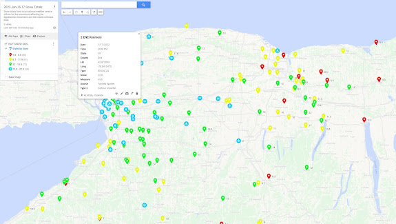
I really like some of the new National Weather Service local offices' snow observations pages, especially State College, PA that has this very slick graphics. A few years ago, I played around with MyMaps in Google Maps and learned to create a simple google map with pins for snowfall at various locations.
Unfortunately, Buffalo didn't have one of these snow maps so I created this - the jackpot was 2 miles ENE of Kenmore Avenue in Buffalo where a trained spotter recorded 22.8" of snow at 6:18PM on Jan 17th from this storm (ok and a little help from lake erie)!
Ice coverage on the lakes is below average due to how mild the early winter and late fall was so the lake enhanced and lake effect snow from these last two systems has really been amazing. 19.2 inches of snow fell at the National Weather Service Office at the Buffalo Airport with 17.6 inches in 24 hours. This makes January 17th, 2022 the snowiest for the date on record for BUF, breaking the previous record of 8.3 inches on this date. And this is the 2nd snowiest January day record broken in just two weeks as January 6, 2022 now holds that honor as well. 43.2 inches of snow has now fallen in Buffalo this month which is 28 inches above the normal 15.2 that typically falls so far in a season. Send some to NYC!
No comments:
Post a Comment