Overnight update: GFS shows the Tue system much weaker and dryer - 1" all around the NY metro.
I am shifting my attention to the main event which should be on Thursday where a major coastal storm develops off the delmarva - will it track out to sea or move up the coast?
Washington DC snow weenies were up late last night tweeting and posting their hearts out over this:
The GFS showing a cool 30" over western VA and the snow hole that has been Washington, DC disappearing with 12" of fresh powder dumped on the nation's capital on Friday night. This is storm #2 we are watching for Thursday into Friday. Thanks to @lockitin on Twitter for "The most outrageous weather model outputs #LOCKITIN".
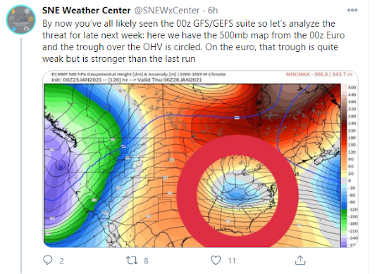
I thought SNEWxCenter had the most thoughtful twitter discussion of this set up and the series of maps showing what to look for. The takeaway?
First, the GFS has high pressure creeping down near SE Canada and giving some separation between the two ocean storms for the 29th storm. That gives the blocking required to push the Low closer to the coast. Notice the wide spread of low pressure locations on the Euro ensemble - need more data to come up with the correct solution but some members are rather close to the east coast and some OTS.
And second, the trough amplitude in the ohio valley. If you look at the 500mb, Euro has a much weaker less amplified low across the lower OH valley. GFS has high energy closed low that digs south and this is an important ingredient for any type of nor'easter as it moves eastward. Historically we would write this off with the Euro typically much more accurate than GFS this far out but forecast accuracy has improved in the GFS in recent years and so you might weight the GFS solution a little higher as we think about forecasting this.


No comments:
Post a Comment