There are two snow chances for us snow-starved east coasters. A very strong mid Atlantic storm will graze the NY area today. This one has good snow potential for Washington, DC, SNJ, and even coastal Virginia and Delaware. What a strange winter where NY has no measurable snowfall in January but the mid atlantic is going to get walloped with over 6" in places like Fredericksburg, VA that get that much an entire season some years get it in a day! Bigger threat for the NY metro coming on Friday. More to come on that later but it's a classic nor'easter set up with the models still waffling back and forth right now so we should have better clarity mid week.
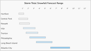
My forecast is for an inch or two in the NY metro today. This storm has a very interesting and sharp snow accumulation gradient. Some places will get 6" (south of Philly) and just 20 miles north they will get a dusting or an inch. Also look out for eastern long island and SNE to get a surprise 6" somewhere along the coast. Weird.
This storm was interesting in that it was OTS (out to sea) and each run of the models brought it further west right up to last night.
My favorite maps for this storm come from NY Metro Wx. The Washington Post also has a great weather team so I am watching Capital Weather Gang for this one. They reported snow falling at 5:45am in DC and increased their forecast to 4-8" in DC and 5-10" south.

On a separate note, I've gotten some feedback that my blog is unreadable because it's too technical so this year I am going to make it more accessible. Thank you for your feedback! I also have secured my first domain name. https://weathermatt.blog/ is coming soon with a more accessible tone!
No comments:
Post a Comment